Edgegenix Cloud AI aggregates every field signal — from IoT sensors, cameras, drones, and vehicle telemetry — into a single verified Common Operating Picture. The Agent makes the call at the edge in milliseconds, then syncs to the operations centre to verify across every source and preserve an audit-grade evidence trail.
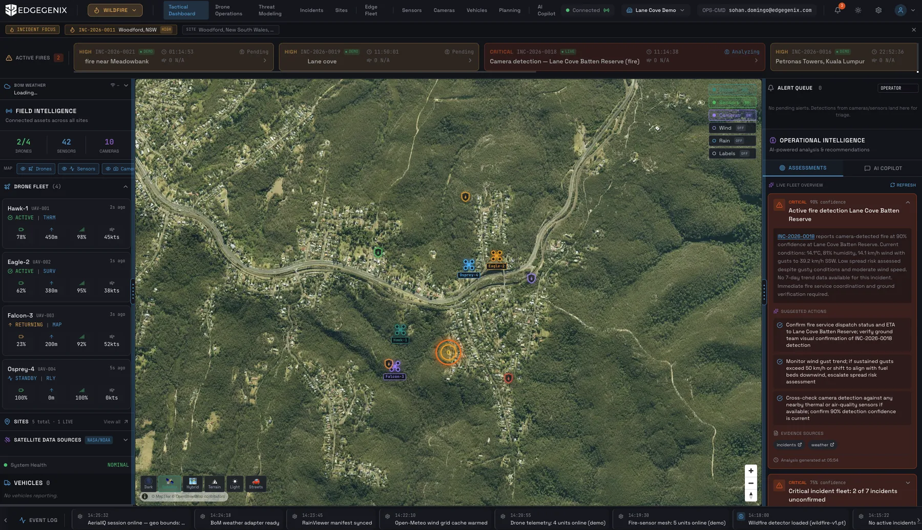
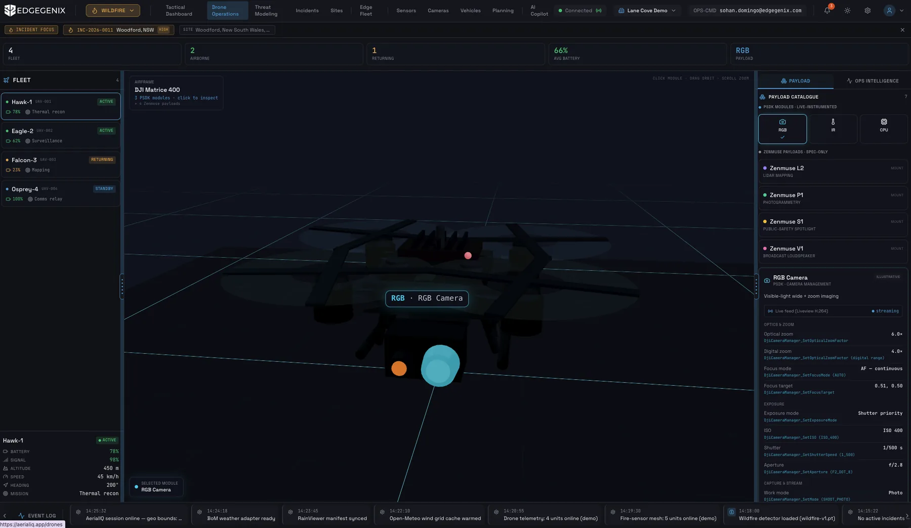
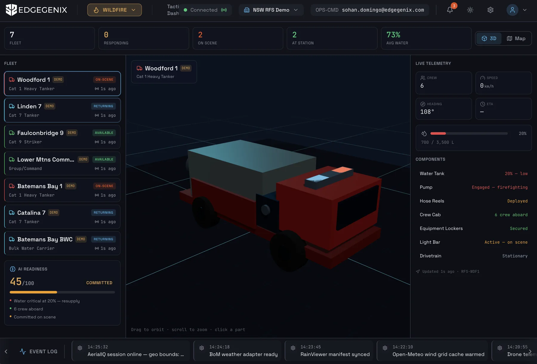
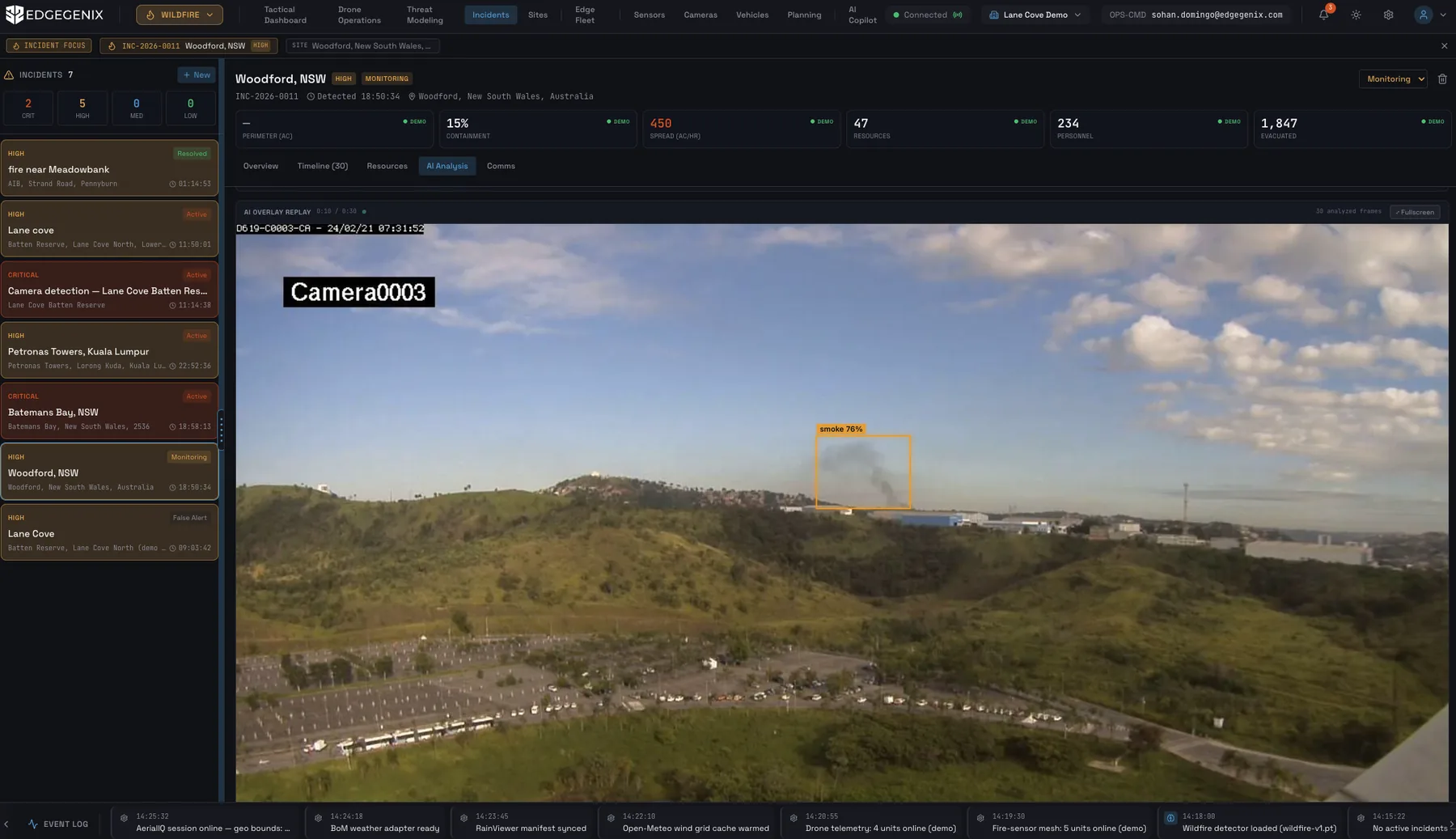
Four views from the live Cloud AI application — real screenshots from the ops centre.
Tactical DashboardLive COP — all drones, sensors, and incidents on one GIS map with AI alerts surfaced in real time.
Drone Operations3D fleet management — airframe telemetry, payload configuration, and live sensor control per drone.
Truck OperationsVehicle-mounted sensor suite — live telemetry, field unit status, and on-asset AI feed from the ground.
Incident IntelligenceFull incident workspace — AI overlay replay, containment metrics, and prioritised suggested actions.
How it works
Field data becomes operational intelligence.
The Edgegenix AI Operational Platform connects cameras, sensors, drones, satellites, weather, GIS, and operational records — then applies Vision AI, language models, and autonomous agents to classify what matters, rank severity, trigger the right actions, and deliver one verified Common Operating Picture with a complete audit trail.
Drones & aircraft
Fixed cameras
IoT sensors
Satellite imagery
Weather & environmental
GIS & maps
Assets & infrastructure
Field reports & logs
External systems & APIs
1
Field layer
Connect everything. Every signal from the field arrives in one place — live, timestamped, ready to reason over.
2
Data ingestion
Understand everything. Every signal is enriched with location, asset history, weather, and operational context before AI ever sees it.
3
AI / ML & analytics
Detect, predict, prioritise. Vision, geospatial AI, sensor models, language and risk ranking turn raw data into ranked findings.
4
Operational intelligence
Act with confidence. Dashboards, alerts, actions, workflows and APIs — all tied to evidence and human review.
Verified findingREADY FOR REVIEW
TypeVegetation encroachment
LocationSector 4G
SeverityHigh
ActionInspect / escalate
IMG_0047.jpgSENSOR_LOGTHERMAL_3D
FIELD SIGNAL→VERIFIED DECISION→RECOMMENDED ACTION→SHARED OPERATION VIEW→EVIDENCE RECORD
The agent layer
Agents that monitor, reason, recommend, and record.
Cloud AI platform · agent layer
MONITORINGSignal watch
VERIFICATIONCross-check
RECOMMENDATIONNext-step logic
REPORTINGEvidence draft
WORKFLOWHandoff & escalation
MONITORING
Watches approved field signals and flags events that need review.
VERIFICATION
Cross-checks source media, sensor context, location, weather, and history.
RECOMMENDATION
Suggests next steps using severity, confidence, and SOP logic.
REPORTING
Drafts incident summaries, evidence records, and briefings.
WORKFLOW
Creates handoffs, escalation notes, and evidence packages.
Designed for operational control, not black-box autonomy. Decisions that affect safety, response, or field action remain reviewable and auditable.
Common Operating Picture
All field signals unified into one live dashboard. The COP updates in real time, surfacing what matters and suppressing noise so operators stay in command.
AI Verification Engine
Every finding is cross-verified across multiple sources before it reaches an operator. Confidence scores, evidence links, and a plain-language explanation with every alert.
Audit-Grade Evidence Trail
Every decision, every alert, and every agent action is timestamped and stored with its evidence. Court-admissible records for compliance, incident review, and chain-of-command accountability.
Agent Orchestration
Cloud AI orchestrates the full agent mesh — coordinating Edge AI nodes, ECIA connectivity agents, and external data feeds into a single, coherent operational picture.
Operator Copilot
Natural-language interface for operators to query the live picture: 'What changed in Sector 4 in the last 30 minutes?' Answers grounded in verified field data.
Open Integration
REST APIs and webhooks connect to existing CAD systems, radio infrastructure, SCADA, and reporting tools. No rip-and-replace required.
Architecture
Two-tier: Edge decides. Cloud verifies.
Cloud AI is the operations-centre tier of the Edgegenix platform. It receives verified findings from Edge AI nodes and ECIA agents, re-verifies them at the fleet level, and presents operators with a coherent, prioritised operational picture.
Cloud tier
Edgegenix Cloud AI
Live COP aggregation from all field sources
Fleet-wide re-verification and confidence scoring
Audit-grade evidence storage
Operator copilot (natural-language queries)
Agent mesh orchestration
REST API & webhook integration
Field tiers (feeds Cloud AI)
Edge AI + ECIA agents
Edge AI: on-device vision AI detection
ECIA: on-vehicle connectivity agents
Offline operation with store-and-forward
Sub-second edge decisions
Syncs to Cloud AI on reconnect
The Edgegenix platform
Three products. One intelligence layer.
Deploy standalone or as a unified stack — from the AI box on the vehicle to the operations centre in the cloud.
CURRENT PAGE
Cloud AI
Operations centre. Live COP, AI verification, agent orchestration, and audit-grade evidence trail.
Edge AI
On-asset vision AI. Detects smoke, wildfire, and objects offline — reports verified findings on reconnect.